All amounts are in United States dollars, unless otherwise stated
TORONTO, July 23, 2024 (GLOBE NEWSWIRE) -- Alamos Gold Inc. (TSX:AGI; NYSE: AGI) (“Alamos” or the “Company”) today reported new results from underground and surface drilling at the Island Gold Mine. Exploration drilling continues to extend high-grade gold mineralization across the Island Gold Deposit, as well as within several hanging wall and footwall structures. Delineation and definition drilling has defined wide, higher-grade zones within the Island East area. This is expected to drive further growth in high-grade Mineral Reserves and Resources with the year end update.
Additionally, high-grade mineralization was intersected in the North Shear and the Webb Lake stock area, highlighting a longer-term, near-mine opportunity as a potential source of additional mill feed for the expanded Magino milling complex.
"We continue to have broad-based exploration success across the Island Gold deposit. This includes within the main structure, which remains open laterally and down-plunge, as well as within an increasing number of hanging wall and footwall structures. This is expected to contribute to another year of growth in high-grade Mineral Reserves and Resources, as Island Gold continues to establish itself as one of the highest-grade and fastest growing deposits in the world. This growth is supporting a longer mine life at Island Gold, which already exceeds 20 years, and additional synergies to be realized by processing Island Gold ore through the larger Magino mill,” said John A. McCluskey, President and Chief Executive Officer.
“We are also starting to define longer-term upside opportunities through the integration of Island Gold and Magino. This includes the ability to expand the Magino pit onto the larger Island Gold District land package, and identifying and evaluating near mine, higher-grade targets like the North Shear which have the potential to provide additional mill feed to the larger Magino milling complex,” Mr. McCluskey added.
Island Gold Main zone exploration highlights: high-grade mineralization extended outside of Mineral Reserves and Resources in the E1E and C-Zones. These zones are the main structures which host the majority of currently defined Mineral Reserves and Resources at Island Gold. New highlights include1:
- Island West (C-Zone)
- 36.54 g/t Au (15.16 g/t cut) over 7.20 m (890-461-03);
- 56.13 g/t Au (15.35 g/t cut) over 2.13 m (790-479-68);
- 42.25 g/t Au (36.15 g/t cut) over 2.82 m (490-456-54);
- 23.88 g/t Au (14.46 g/t cut) over 3.82 m (1025-517-22); and
- 25.88 g/t Au (25.88 g/t cut) over 2.26 m (1025-517-14).
- Island East (E1E-Zone)
- 17.24 g/t Au (17.24 g/t cut) over 9.97 m (1040-619-24);
- 28.66 g/t Au (28.66 g/t cut) over 2.22 m (MH39-01); and
- 11.75 g/t Au (11.75 g/t cut) over 3.91 m (MH39-03).
Island Gold Hanging Wall and Footwall exploration highlights: high-grade gold mineralization intersected within recently defined hanging wall and footwall zones across the main Island Gold Deposit. These zones represent significant opportunities to continue to grow near mine Mineral Reserves and Resources which are low-cost to develop and produce given their proximity to existing infrastructure. New highlights include1:
- Island West Hanging Wall Zones
B Zone
- 79.93 g/t Au (18.53 g/t cut) over 2.01 m (1025-517-08);
- 17.34 g/t Au (11.70 g/t cut) over 2.49 m (490-456-14); and
- 16.55 g/t Au (16.17 g/t cut) over 2.01 m (890-461-01).
NS2 Zone: a new parallel structure to the NS1 Zone, located 100 m to the east.
- 55.98 g/t Au (55.98 g/t cut) over 2.10 m (1025-517-28);
- 34.85 g/t Au (34.85 g/t cut) over 2.10 m (1025-517-22); and
- 9.28 g/t Au (9.28 g/t cut) over 5.56 m (900-506-13).
- Island East Footwall Zones
E1D1 Zone
- 72.57 g/t Au (49.74 g/t cut) over 2.01 m (945-624-42);
- 12.43 g/t Au (12.43 g/t cut) over 3.86 m (945-624-30); and
- 21.04 g/t Au (17.30 g/t cut) over 2.09 m (945-624-41A).
NTH4 Zone
- 27.73 g/t Au (12.80 g/t cut) over 1.96 m (945-624-59).
Other Hanging Wall and Footwall intersections: drilling continues to intersect high-grade mineralization in proximity to existing underground infrastructure in yet to be defined zones. These are part of more than 2,000 intersections above 3 g/t Au outside of existing Mineral Reserves and Resources in the hanging wall and footwall, highlighting the opportunity for significant near-mine additions as ongoing drilling further defines these areas. New highlights include2:
Footwall
- 88.44 g/t Au over 4.65 m (890-461-30);
- 32.35 g/t Au over 4.00 m (890-461-02);
- 28.79 g/t Au over 4.25 m (1130-623-09);
- 28.60 g/t Au over 4.15 m (840-530-07A);
- 38.20 g/t Au over 2.70 m (945-624-21); and
- 10.59 g/t Au over 10.55 m (1040-619-22).
Hanging Wall
- 64.67 g/t Au over 5.95 m (890-461-03);
- 84.87 g/t Au over 3.00 m (580-473-40);
- 53.30 g/t Au over 4.50 m (890-461-03);
- 63.12 g/t Au over 3.50 m (945-624-39);
- 18.38 g/t Au over 10.70 m (1040-619-32); and
- 65.77 g/t Au over 2.25 m (580-473-39).
Island Gold East delineation and definition drilling highlights: ongoing drilling focused on the conversion of Mineral Resources to Reserves from the 945, 1040, and 1130-levels has defined wider, higher-grade zones over an 80 m by 130 m area within the Island Main structure. New highlights include1:
- 102.42 g/t Au (68.19 g/t cut) over 17.19 m (1040-619-28);
- 135.39 g/t Au (94.41 g/t cut) over 8.28 m (1040-619-27);
- 101.13 g/t Au (53.97 g/t cut) over 5.23 m (1130-623-20);
- 37.63 g/t Au (29.59 g/t cut) over 12.54 m (1130-623-33);
- 19.95 g/t Au (16.93 g/t cut) over 19.66 m (1130-623-01); and
- 33.66 g/t Au (22.31 g/t cut) over 11.15 m (1040-619-31).
Island Gold District – Near Mine Exploration
North Shear: high-grade gold mineralization intersected north and west of the Island Gold Deposit, towards the Magino open pit. This area is located immediately east of the Magino open pit, within two kilometres (“km”) of the Magino mill, and represents a longer-term opportunity as a source of additional mill feed. New highlights include1:
- 12.10 g/t Au over 4.32 m, including 34.90 g/t Au over 1.38 m (24IGX071);
- 2.09 g/t Au over 6.01 m, including 16.75 g/t Au over 0.28 m (24IGX072); and
- 3.65 g/t Au over 4.92 m, including 10.20 g/t Au over 0.87 m (24IGX073).
Webb Lake Stock: gold mineralization intersected east of the Magino open pit Mineral Reserve supporting the potential for expansion of the Magino deposit to the east beyond the previous Magino/Island Gold property boundary (pre-acquisition by Alamos). New highlights include2:
- 15.52 g/t Au over 5.64 m, including 179.00 g/t Au over 0.47 m (24IGX071);
- 7.97 g/t Au over 7.43 m, including 153.50 g/t Au over 0.30 m (24IGX073); and
- 17.96 g/t Au over 1.21 m (IGX24073).
1 All reported composite intervals are calculated true width of the mineralized zones, unless otherwise stated. Drillhole composite intervals reported as “cut” may include higher grade samples which have been cut to: Island West (C-zone) and Island Main @ 225 g/t Au; Island Main and East (E1E Zone) @ 185 g/t Au; E1D1 and NS2 @ 90 g/t Au; NTH4 @ 75 g/t. North Shear and Webb Lake Stock composites reported as uncut.
2 All reported composite intervals are core length, true width is unknown at this time, and gold grades are reported as uncut.
New highlight intercepts can be found in Tables 1 and 2, and in Figures 1 to 4 at the end of this news release.
2024 Exploration Drilling Program
A total of $19 million is budgeted for exploration at Island Gold in 2024, up from $14 million in 2023, with both a larger near mine and regional exploration program planned for the year. The 2024 exploration program is following up on a successful 2023 program with high-grade Mineral Reserves and Resources added across the main Island Gold structure, as well as within multiple structures in the hanging wall and footwall.
A total of 41,000 m of underground exploration drilling is planned in 2024. The focus is on defining new Mineral Reserves and Resources in proximity to existing production horizons and infrastructure, as well as the conversion of the large existing Mineral Resource base to Mineral Reserves. This includes drilling across the strike extent of the main Island Gold Deposit (E1E and C-Zones), as well as within a growing number of newly defined hanging-wall and footwall zones. To support the underground exploration drilling program, 460 m of underground exploration drift development is planned to extend drill platforms on the 850, 945, and 1025-levels.
In addition to the exploration budget, 32,000 m of underground delineation drilling has been planned and included in sustaining capital for Island Gold which will be focused on the conversion of the large Mineral Resource base to Mineral Reserves. Additionally, 12,500 m of near-mine surface exploration drilling has been budgeted, and 10,000 m of regional exploration drilling.
To the end of June 2024, 28,003 m of underground exploration drilling had been completed in 111 holes, and 5,882 m of surface drilling had been completed in seven holes. Additionally, 20,885 m of underground delineation drilling was completed in 91 holes.
The regional exploration drilling program also continued through the first half of the year, with 4,995 m of drilling completed in 15 holes.
Island West
Underground Exploration Drilling
Underground drilling extended high-grade gold mineralization 250 m to the west, and up-plunge from existing Mineral Reserves and Resources in the middle portion of Island West. Drilling is being conducted from the 490-level, 790-level, and the 1025-level exploration drifts, between vertical depths of 400 m and 1,200 m. New highlights include1:
- Island West (C-Zone)
- 36.54 g/t Au (15.16 g/t cut) over 7.20 m (890-461-03);
- 56.13 g/t Au (15.35 g/t cut) over 2.13 m (790-479-68);
- 42.25 g/t Au (36.15 g/t cut) over 2.82 m (490-456-54);
- 23.88 g/t Au (14.46 g/t cut) over 3.82 m (1025-517-22);
- 25.88 g/t Au (25.88 g/t cut) over 2.26 m (1025-517-14);
- 5.11 g/t Au (5.11 g/t cut) over 9.72 m (850-475-12);
- 16.95 g/t Au (7.53 g/t cut) over 2.57 m (790-479-59); and
- 11.96 g/t Au (11.96 g/t cut) over 3.03 m (1025-517-02).
Island West Hanging Wall Zones
In addition to testing the main Island Gold structure (C-Zone), underground exploration drilling continued to target high-grade gold mineralization in sub-parallel and perpendicular structures in the hanging wall from the 490, 890, 900, and 1025-levels.
NS1 and NS2 Hanging Wall Zones
The NS1 zone is a north-striking structure with a high-angle orientation relative to the C-Zone that was discovered in early 2023. The first stopes were mined from the NS1 zone during the second half 2023 and it continues to be actively mined in 2024, highlighting the near-term opportunities within these hanging wall and footwall zones.
In early 2024, the NS2 zone, a new sub-parallel north-strike zone was discovered 100 m east of the NS1 zone. To date, this zone has been defined over a vertical extent of 300 m, and defined over an average strike of 100 m.
In addition, several other north-striking high-angle structures have been identified across the deposit from reinterpretation of historical hanging wall drilling, which will be further evaluated as underground exploration drilling advances.
New highlights from the Island West Hanging Wall zones include (Figure 2, Table 1):
- Island West Hanging Wall Zones
B Zone
- 79.93 g/t Au (18.53 g/t cut) over 2.01 m (1025-517-08);
- 17.34 g/t Au (11.70 g/t cut) over 2.49 m (490-456-14); and
- 16.55 g/t Au (16.17 g/t cut) over 2.01 m (890-461-01).
NS2 Zone: a new parallel structure to the NS1 Zone, located 100 m to the east.
- 55.98 g/t Au (55.98 g/t cut) over 2.10 m (1025-517-28);
- 34.85 g/t Au (34.85 g/t cut) over 2.10 m (1025-517-22); and
- 9.28 g/t Au (9.28 g/t cut) over 5.56 m (900-506-13).
Island East
Surface and Underground Exploration Drilling
Underground drilling from the 945 Exploration Drift and Island East Ramp, continues to extend high-grade gold mineralization along strike to the east of Mineral Reserves and Resources in the middle portion of Island East (between vertical depths of 900 m and 1,300 m).
In addition, surface drilling successfully defined high-grade gold mineralization within a large 200 m by 400 m gap in Mineral Reserves and Resources between 1,100 m and 1,300 m depths. This included holes MH39-01 (28.66 g/t Au (28.66 g/t cut) over 2.22 m) and MH 39-03 (11.75 g/t Au (11.75 g/t cut) over 3.91 m). Following the completion of the surface drilling program, additional drilling will be completed as underground development and drill platforms are established closer to this area.
New highlights in the E1E-Zone include (Figure 1, Tables 1 and 2):
- Island East (E1E-Zone)
- 17.24 g/t Au (17.24 g/t cut) over 9.97 m (1040-619-24);
- 28.66 g/t Au (28.66 g/t cut) over 2.22 m (MH39-01); and
- 11.75 g/t Au (11.75 g/t cut) over 3.91 m (MH39-03).
Underground Delineation Drilling
Delineation and definition drilling focused on Mineral Resource conversion from the 945, 1040, and 1130-levels continues to define wide, higher-grade zones in Island East. This includes an 80 m by 130 m zone with significantly higher than average grades and widths relative to the rest of the Island Gold deposit. This is expected to support further growth in high-grade Mineral Reserves. New highlights include1:
- 102.42 g/t Au (68.19 g/t cut) over 17.19 m (1040-619-28);
- 135.39 g/t Au (94.41 g/t cut) over 8.28 m (1040-619-27);
- 101.13 g/t Au (53.97 g/t cut) over 5.23 m (1130-623-20);
- 37.63 g/t Au (29.59 g/t cut) over 12.54 m (1130-623-33);
- 19.95 g/t Au (16.93 g/t cut) over 19.66 m (1130-623-01);
- 33.66 g/t Au (22.31 g/t cut) over 11.15 m (1040-619-31);
- 29.75 g/t Au (29.75 g/t cut) over 9.89 m (945-624-53);
- 51.19 g/t Au (26.03 g/t cut) over 5.26 m (1040-619-29);
- 100.65 g/t Au (94.10 g/t cut) over 2.51 m (1040-619-27);
- 27.70 g/t Au (26.52 g/t cut) over 8.35 m (945-624-55);
- 65.89 g/t Au (44.50 g/t cut) over 3.42 m (1130-623-14);
- 13.24 g/t Au (9.85 g/t cut) over 15.87 m (1130-623-29);
- 26.22 g/t Au (26.22 g/t cut) over 7.90 m (1130-623-19);
- 26.03 g/t Au (15.22 g/t cut) over 5.17 m (1040-619-30); and
- 21.68 g/t Au (20.20 g/t cut) over 5.84 m (1130-632-19).
Island East Footwall Zones
In addition to testing the E1E-Zone, underground exploration drilling continued to target high-grade gold mineralization in structures in the footwall from the 945 and 1015-levels. These structures were included in the year-end 2023 Mineral Reserves and Resources. Additional drilling in 2024 has been successful in confirming the continuity and extending high-grade gold mineralization within the E1D1 and NTH4 zones, located 10 m and 60 m from the E1E-Zone, respectively.
New highlights from the Island East Footwall zones include (Figure 2, Table 1):
E1D1 Zone
- 72.57 g/t Au (49.74 g/t cut) over 2.01 m (945-624-42);
- 12.43 g/t Au (12.43 g/t cut) over 3.86 m (945-624-30);
- 21.04 g/t Au (17.30 g/t cut) over 2.09 m (945-624-41A);
- 6.25 g/t Au (4.85 g/t cut) over 5.85 m (945-624-55); and
- 16.21 g/t Au (11.31 g/t cut) over 2.02 m (1015-624-10).
NTH4 Zone
- 27.73 g/t Au (12.80 g/t cut) over 1.96 m (945-624-59).
As with the hanging wall and footwall zones in Island West, these footwall zones in Island East highlight the potential to add high-grade Mineral Reserves and Resources in proximity of existing production horizons and infrastructure which would be low-cost to develop and mine.
Other Zones
The majority of Island Gold’s Mineral Reserves and Resources and main production horizons are hosted in the C/E1E structure. The Island Gold Deposit also consists of a growing number of sub-parallel and high-angle mineralized structures outside of the main C/E1E-Zone. As underground development advances, these sub-parallel hanging wall and footwall structures can be targeted and defined with step-out drilling from underground drill platforms.
As demonstrated in 2023, these zones and other targets within the hanging wall and footwall represent significant opportunities to continue defining additional high-grade Mineral Reserves and Resources in proximity to existing underground infrastructure. These additions continue to enhance the ounce per vertical metre profile and provide additional operational flexibility with multiple mining horizons from the same lateral development levels.
The following are highlights of new hanging wall and footwall intersections from underground exploration drilling where the geometry and continuity are not yet established (“Unknown Zone”). These are part of more than 2,000 intersections above 3 g/t Au within recently defined and yet to be defined zones in the hanging wall and footwall. These intersections are outside of existing Mineral Reserves and Resources, highlighting the opportunity for significant near-mine additions as ongoing drilling further defines these areas.
New highlights include (reported composite intervals are uncut and as core length, as true width is unknown at this time) (Table 1):
Footwall
- 88.44 g/t Au over 4.65 m (890-461-30);
- 32.35 g/t Au over 4.00 m (890-461-02);
- 28.79 g/t Au over 4.25 m (1130-623-09);
- 28.60 g/t Au over 4.15 m (840-530-07A);
- 38.20 g/t Au over 2.70 m (945-624-21);
- 10.59 g/t Au over 10.55 m (1040-619-22);
- 20.53 g/t Au over 4.15 m (1040-619-33);
- 32.37 g/t Au over 2.60 m (1130-623-18);
- 21.22 g/t Au over 3.90 m (890-461-21);
- 7.41 g/t Au over 8.60 m (840-530-10);
- 26.28 g/t Au over 2.40 m (1040-619-34);
- 10.49 g/t Au over 5.60 m (1040-619-24);
- 15.87 g/t Au over 3.40 m (1040-619-32);
- 10.98 g/t Au over 4.85 m (1040-619-36); and
- 19.50 g/t Au over 2.60 m (840-632-47).
Hanging Wall
- 64.67 g/t Au over 5.95 m (890-461-03);
- 84.87 g/t Au over 3.00 m (580-473-40);
- 53.30 g/t Au over 4.50 m (890-461-03);
- 63.12 g/t Au over 3.50 m (945-624-39);
- 18.38 g/t Au over 10.70 m (1040-619-32);
- 65.77 g/t Au over 2.25 m (580-473-39);
- 33.02 g/t Au over 4.00 m (850-475-25);
- 41.53 g/t Au over 2.85 m (850-475-26);
- 20.75 g/t Au over 5.45 m (890-461-10);
- 40.05 g/t Au over 2.30 m (900-506-14);
- 17.59 g/t Au over 4.40 m (890-461-14);
- 10.50 g/t Au over 6.82 m (945-624-39);
- 15.94 g/t Au over 4.00 m (945-624-40);
- 11.60 g/t Au over 4.85 m (1025-517-24); and
- 22.23 g/t Au over 2.40 m (1025-517-10).
Island Gold District – Near Mine Exploration
As part of the near-mine exploration program, high-grade gold mineralization was intersected in surface drilling completed to the north and west of the Island Gold Deposit, and east of the Magino open pit, within the North Shear and Webb Lake Stock.
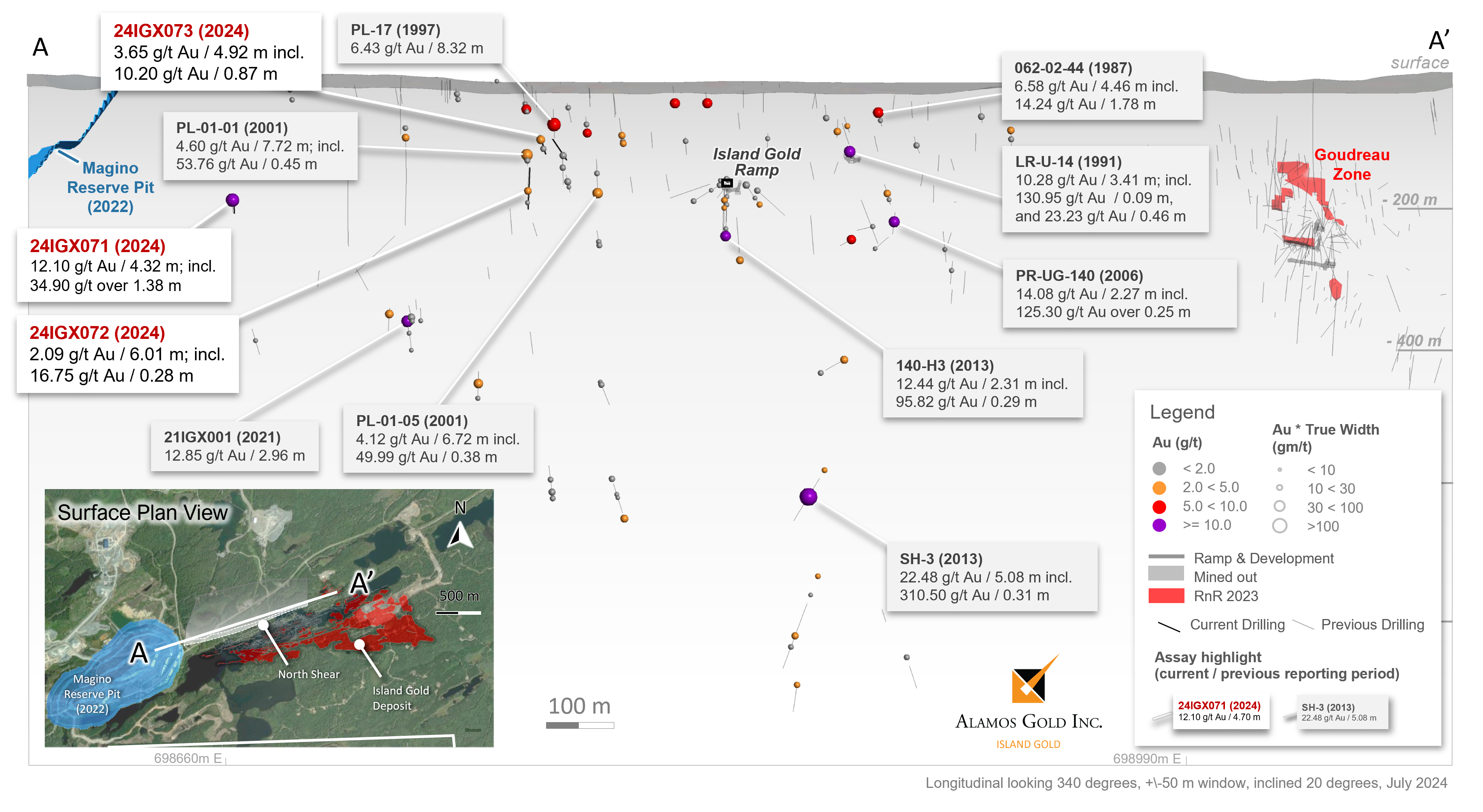
North Shear
The North Shear Corridor is located on the north limb of an antiform, within and along the northern portion of the Webb Lake Stock, dipping to the north. The Island Gold Deposit is located on the southern limb of the antiform, and dips to the south (Figure 3).
Patricia Mines initially defined the North Shear in 1999 after reviewing drilling completed in the 1980’s and 1990’s. There has been limited drilling within the North Shear since that time, as the focus of exploration had shifted to the Island Gold Deposit.
The North Shear Corridor is 20 to 30 m wide near surface, and appears to widen at depth to 60 m, based on interpretation from wider spaced historical drilling. The North Shear has been interpreted to be over 1,000 m in strike, drilled to a depth of 600 m, and remains open at depth (Figure 3 and 4).
The North Shear is located within 2 km of the Magino mill and adjacent to the Island Gold deposit with the existing Island Gold ramp running through the target. The ramp system could be leveraged to test and ultimately develop the North Shear as a longer-term potential source of additional mill feed within the expanded Magino mill complex. Additional modelling, interpretation and drilling are planned to evaluate the North Shear for underground bulk mining potential.
Highlights from historic drilling within the North Shear Corridor include3:
- 22.48 g/t Au over 5.08 m, including 310.50 g/t Au over 0.31 m (SH-3, 2013);
- 6.43 g/t Au over 8.32 m, including 28.55 g/t Au over 0.39 m, 30.21 g/t over 0.58 m, and 37.65 g/t over 0.38 m (PL-17, 1997);
- 12.85 g/t Au over 2.96 m, including 106.00 g/t Au over 0.34 m (21IGX001, 2021);
- 4.60 g/t Au over 7.72 m, including 53.76 g/t Au over 0.45 m (PL-01-01, 2001);
- 10.28 g/t Au over 3.41 m, including 130.95 g/t Au over 0.09 m, and 23.23 g/t Au over 0.46 m (LR-U-14, 1991);
- 14.08 g/t Au over 2.27 m, including 125.30 g/t Au over 0.25 m (PR-UG-140, 2006);
- 6.58 g/t Au over 4.46 m, including 14.24 g/t Au over 1.78 m (062-02-44, 1987);
- 12.44 g/t Au over 2.31 m, including 95.82 g/t Au over 0.29 m (140-H3, 2013); and
- 4.12 g/t Au over 6.72 m, including 49.99 g/t Au over 0.38 m (PL-01-05, 2001).
3 All reported composite intervals are calculated true width of the mineralized zones, and gold grades are reported as uncut. Composites were generated at a 0.75 g/t Au cut-off grade, with no more than 2.0 m of consecutive internal waste.
Four drill holes were completed in the second quarter of 2024 to test both the North Shear and Webb Lake Stock east of the Magino deposit. All four the drill holes intersected gold mineralization in the North Shear. New highlights include1:
- 12.10 g/t Au over 4.32 m, including 34.90 g/t Au over 1.38 m (24IGX071);
- 2.09 g/t Au over 6.01 m, including 16.75 g/t Au over 0.28 m (24IGX072) and
- 3.65 g/t Au over 4.92 m, including 10.20 g/t Au over 0.87 m (24IGX073).
- 0.98 g/t Au over 11.04 m (24IGX074).
Webb Lake Stock
The Magino Gold Deposit is hosted within the Webb Lake Stock. Drilling to the east of the planned Magino Mineral Reserve pit intersected gold mineralization east of the former Magino property boundary both in the North Shear, as described above, and to the south within and along the southern contact of the Webb Lake Stock.
High-grade gold mineralization intersected in 24IGX073 (7.97 g/t Au over 7.43 m including 153.50 g/t Au over 0.30 m) is associated with strong shearing developed along the southern margin of the Webb Lake stock at the contact with a diorite. This southern shear zone requires additional drilling to define the geometry and extent of gold mineralization with the shear.
The former land tenure boundary with Island Gold (pre-acquisition) previously limited the extent of the Magino deposit to the east. The removal of this boundary, and the intersection of additional gold mineralization to the east further supports the potential for the Magino deposit to be extended onto the Island Gold property. New highlights include2:
- 15.52 g/t Au over 5.64 m, including 179.00 g/t Au over 0.47 m (24IGX071);
- 7.97 g/t Au over 7.43 m, including 153.50 g/t Au over 0.30 m (24IGX073);
- 17.96 g/t Au over 1.21 m, including 35.50 g/t Au over 0.58 m (IGX24073).
- 3.41 g/t Au over 2.76 m, including 10.25 g/t Au over 0.40 m (24IGX072); and
- 7.19 g/t Au over 1.71 m, including 13.50 g/t Au over 0.83 m (24IGX072).
Mineral Reserve and Resource expansion drilling is planned in the second half of 2024 to evaluate both the North Shear and Webb Lake Stock near surface, immediately to the east of the Magino Mineral Reserve pit, which remains open to the east.
Qualified Persons
Scott R.G. Parsons, P.Geo., FAusIMM, Alamos Gold’s Vice President, Exploration, has reviewed and approved the scientific and technical information contained in this news release. Scott R.G. Parsons is a “Qualified Person” as defined by Canadian Securities Administrators’ National Instrument 43-101 - Standards of Disclosure for Mineral Projects.
Exploration programs at the Island Gold Mine are directed and supervised by Tyler Poulin, P.Geo., Chief Geologist at the Island Gold Mine. Tyler Poulin is a “Qualified Person” as defined by Canadian Securities Administrators’ National Instrument 43-101 - Standards of Disclosure for Mineral Projects.
Quality Assurance and Quality Control
Alamos Gold maintains an internal Quality Assurance / Quality Control (QA/QC) program at the Island Gold Mine to ensure sampling and analysis of all exploration work is conducted in accordance with best practices.
Access to the Island Gold Mine is controlled by security personnel. Drill core is logged and sampled at core logging facilities within the mine site under the supervision of a Qualified Geologist. A geologist marks the individual samples for analysis, and sample intervals, sample numbers, standards and blanks are entered into the database. Exploration core is cut in half using an electric core saw equipped with a diamond tipped blade. One half of the core is placed into a plastic sample bag and sealed with zip ties in preparation for shipment. The other half of the core is returned to the core box and retained for future reference. Approximately 20% of all delineation core is cut and stored, and the entire core sample is sent for analysis on all definition programs. The samples are placed in large heavy-duty nylon reinforced Fabrene bags, which are identified and sealed before being placed on pallets. The core samples are picked up at the mine site and mine samples are delivered to AGAT and Actlabs laboratories, and regional samples are delivered to ALS laboratory, all located in Thunder Bay, Ontario.
Gold is analyzed by a 50 grams fire assay with an Atomic Absorption (AA) finish. Mine samples greater than 10.0 g/t Au, and regional samples greater than 5.0 g/t Au are re-analyzed using gravimetric finish methods. AGAT, Actlabs and ALS are certified laboratories and have internal quality control (“QC”) programs that include insertion of reagent blanks, reference materials, and pulp duplicates.
The Corporation inserts QC samples (blanks and reference materials) at regular intervals to monitor laboratory performance. Cross check assays are completed on a regular basis in a secondary accredited laboratory. The Island Gold Mine QA/QC procedures are more completely described in the August 29, 2022 Technical Report filed on SEDAR+ (www.sedarplus.ca).
About Alamos
Alamos is a Canadian-based intermediate gold producer with diversified production from three operations in North America. This includes the Young-Davidson mine and Island Gold District in northern Ontario, Canada, and the Mulatos District in Sonora State, Mexico. Additionally, the Company has a strong portfolio of growth projects, including the Phase 3+ Expansion at Island Gold, and the Lynn Lake project in Manitoba, Canada. Alamos employs more than 2,400 people and is committed to the highest standards of sustainable development. The Company’s shares are traded on the TSX and NYSE under the symbol “AGI”.
FOR FURTHER INFORMATION, PLEASE CONTACT:
| Scott K. Parsons | |
| Senior Vice President, Investor Relations | |
| (416) 368-9932 x 5439 |
The TSX and NYSE have not reviewed and do not accept responsibility for the adequacy or accuracy of this release.
Cautionary Note
This news release includes certain statements that constitute forward-looking information within the meaning of applicable Canadian and U.S. securities laws ("forward-looking statements"). All statements in this news release other than statements of historical fact, which address events, results, outcomes, or developments that Alamos expects to occur are forward-looking statements. Forward-looking statements are generally, but not always, identified by the use of forward-looking terminology such as "expect", "plan", "estimate", “target”, “budget”, “prospective” “potential”, “opportunity” or variations of such words and phrases and similar expressions or statements that certain actions, events or results "may", "could", "would", "might" or "will" be taken, occur or be achieved or the negative connotation of such terms.
Such statements in this news release include, without limitation, statements with respect to planned exploration programs, focuses, strategies, drilling targets and work, potential for further exploration of certain areas, potential drilling results and related expectations, costs and expenditures, including with respect to the cost of development and production, project economics, gold price assumptions, potential mineralization, projected ore grades, opportunities to add near mine and further high-grade Mineral Reserves and Resources, potential sources of additional mill feed for an expanded Magino milling complex, potential expansion of the Magino pit, synergies to be realized by processing Island Gold ore through the Magino mill, upside opportunities through the integration of Island Gold and Magino, planned modelling, interpretation and drilling to evaluate the potential of the North Shear near Magino for underground bulk mining potential, expectations regarding the mine plan, mine life, sustaining capital and value of operations and other statements and information that is based on forecasts and projections of future operational, geological or financial results, estimates of amounts not yet determinable and assumptions of management.
Exploration results that include geophysics, sampling, and drill results on wide spacings may not be indicative of the occurrence of a mineral deposit. Such results do not provide assurance that further work will establish sufficient grade, continuity, metallurgical characteristics and economic potential to be classed as a category of Mineral Resource. A Mineral Resource that is classified as "inferred" or "indicated" has a great amount of uncertainty as to its existence and economic and legal feasibility. It cannot be assumed that any or part of an "Indicated Mineral Resource" or "Inferred Mineral Resource" will ever be upgraded to a higher category of Mineral Resource. Investors are cautioned not to assume that all or any part of mineral deposits in these categories will ever be converted into Proven and Probable Mineral Reserves.
Alamos cautions that forward-looking statements are necessarily based upon several factors and assumptions that, while considered reasonable by management at the time of making such statements, are inherently subject to significant business, economic, technical, legal, political and competitive uncertainties and contingencies. Known and unknown factors could cause actual results to differ materially from those projected in the forward-looking statements, and undue reliance should not be placed on such statements and information.
These factors and assumptions include, but are not limited to: the actual results of current exploration activities, conclusions of economic and geological evaluations, changes in project parameters as plans continue to be refined, operations may be exposed to illness, disease, epidemic or pandemic which may impact the broader market; state and federal orders or mandates (including with respect to mining operations generally or auxiliary businesses or services required for the Company’s operations) in Canada, Mexico and other jurisdictions in which the Company does or may conduct business; the duration of regulatory responses to any illness, disease, epidemic or pandemic; changes in national and local government legislation, controls or regulations; failure to comply with environmental and health and safety laws and regulations; labour and contractor availability (and being able to secure the same on favourable terms); ability to sell or deliver gold doré bars; disruptions in the maintenance or provision of required infrastructure and information technology systems; fluctuations in the price of gold or certain other commodities such as, diesel fuel, natural gas, and electricity; operating or technical difficulties in connection with mining or development activities, including geotechnical challenges and changes to production estimates (which assume accuracy of projected ore grade, mining rates, recovery timing and recovery rate estimates and may be impacted by unscheduled maintenance); changes in foreign exchange rates (particularly the Canadian dollar, U.S. dollar, and Mexican peso); the impact of inflation; employee and community relations; litigation and administrative proceedings; disruptions affecting operations; availability of and increased costs associated with mining inputs and labour; delays in the development or updating of mine plans; inherent risks and hazards associated with mining and mineral processing including environmental hazards, industrial accidents, unusual or unexpected formations, pressures and cave-ins; the risk that the Company’s mines may not perform as planned; uncertainty with the Company's ability to secure additional capital to execute its business plans; the speculative nature of mineral exploration and development, risks in obtaining and maintaining necessary licenses, permits and authorizations, contests over title to properties; expropriation or nationalization of property; political or economic developments in Canada or Mexico and other jurisdictions in which the Company does or may carry on business in the future; increased costs and risks related to the potential impact of climate change; the costs and timing of construction and development of new deposits; risk of loss due to sabotage, protests and other civil disturbances; the impact of global liquidity and credit availability and the values of assets and liabilities based on projected future cash flows; and business opportunities that may be pursued by the Company.
For a more detailed discussion of such risks and other factors that may affect the Company's ability to achieve the expectations set forth in the forward-looking statements contained in this news release, see the Company’s latest 40-F/Annual Information Form and Management’s Discussion and Analysis, each under the heading “Risk Factors”, available on the SEDAR+ website at www.sedarplus.ca or on EDGAR at www.sec.gov. The foregoing should be reviewed in conjunction with the information and risk factors and assumptions found in this news release.
The Company disclaims any intention or obligation to update or revise any forward-looking statements, whether written or oral, or whether as a result of new information, future events or otherwise, except as required by applicable law.
Note to U.S. Investors – Mineral Reserve and Resource Estimates
Unless otherwise indicated, all Mineral Resource and Mineral Reserve estimates included in this news release have been prepared in accordance with National Instrument 43-101 - Standards of Disclosure for Mineral Projects (“NI 43-101”) and the Canadian Institute of Mining, Metallurgy and Petroleum (the “CIM”) - CIM Definition Standards on Mineral Resources and Mineral Reserves, adopted by the CIM Council, as amended (the “CIM Standards”). NI 43-101 is a rule developed by the Canadian Securities Administrators, which established standards for all public disclosure an issuer makes of scientific and technical information concerning mineral projects. Mining disclosure in the United States was previously required to comply with SEC Industry Guide 7 (“SEC Industry Guide 7”) under the United States Securities Exchange Act of 1934, as amended. The U.S. Securities and Exchange Commission (the “SEC”) has adopted final rules, to replace SEC Industry Guide 7 with new mining disclosure rules under sub-part 1300 of Regulation S-K of the U.S. Securities Act (“Regulation S-K 1300”) which became mandatory for U.S. reporting companies beginning with the first fiscal year commencing on or after January 1, 2021. Under Regulation S-K 1300, the SEC now recognizes estimates of “Measured Mineral Resources”, “Indicated Mineral Resources” and “Inferred Mineral Resources”. In addition, the SEC has amended its definitions of “Proven Mineral Reserves” and “Probable Mineral Reserves” to be substantially similar to international standards.
Investors are cautioned that while the above terms are “substantially similar” to CIM Definitions, there are differences in the definitions under Regulation S-K 1300 and the CIM Standards. Accordingly, there is no assurance any mineral reserves or mineral resources that the Company may report as “proven mineral reserves”, “probable mineral reserves”, “measured mineral resources”, “indicated mineral resources” and “inferred mineral resources” under NI 43-101 would be the same had the Company prepared the mineral reserve or mineral resource estimates under the standards adopted under Regulation S-K 1300. U.S. investors are also cautioned that while the SEC recognizes “measured mineral resources”, “indicated mineral resources” and “inferred mineral resources” under Regulation S-K 1300, investors should not assume that any part or all of the mineralization in these categories will ever be converted into a higher category of mineral resources or into mineral reserves. Mineralization described using these terms has a greater degree of uncertainty as to its existence and feasibility than mineralization that has been characterized as reserves. Accordingly, investors are cautioned not to assume that any measured mineral resources, indicated mineral resources, or inferred mineral resources that the Company reports are or will be economically or legally mineable.
Cautionary Note regarding non-GAAP Measures and Additional GAAP Measures
Note that for purposes of this section, GAAP refers to IFRS. The Company believes that investors use certain non-GAAP and additional GAAP measures as indicators to assess gold mining companies. They are intended to provide additional information and should not be considered in isolation or as a substitute for measures of performance prepared with GAAP. “Sustaining capital” are expenditures that do not increase annual gold ounce production at a mine site and excludes all expenditures at the Company’s development projects.
Additional GAAP measures that are presented on the face of the Company’s consolidated statements of comprehensive income and are not meant to be a substitute for other subtotals or totals presented in accordance with IFRS, but rather should be evaluated in conjunction with such IFRS measures. This includes “Earnings from operations”, which is intended to provide an indication of the Company’s operating performance and represents the amount of earnings before net finance income/expense, foreign exchange gain/loss, other income/loss, and income tax expense. Non-GAAP and additional GAAP measures do not have a standardized meaning prescribed under IFRS and therefore may not be comparable to similar measures presented by other companies. A reconciliation of historical non-GAAP and additional GAAP measures are detailed in the Company’s Management’s Discussion and Analysis available at www.alamosgold.com.
Table 1: Island Gold – Previously Unreleased Select Composite Intervals from Underground and Surface Mine Exploration Drilling
Composite intervals greater than 3 g/t Au weighted average, capping values:
Island West (C-zone) and Island Main @ 225 g/t Au; Island Main and East (E1E Zone) @ 185 g/t Au; B Zone, E1D1 zone and NS2 @ 90 g/t Au; NTH4 Zone @ 75 g/t Au; DN @ 35 g/t Au.
| Hole ID | Zone | Target Area | From (m) | To (m) | Core Length (m) | True Width (m) | Au Uncut (g/t) | Au Cut (g/t) | Vertical Depth (m) |
| 1025-517-08 | B | Island West Hanging Wall | 144.00 | 146.58 | 2.58 | 2.01 | 79.93 | 18.53 | 1025 |
| 890-461-01 | B | Island West Hanging Wall | 238.55 | 242.25 | 3.70 | 2.01 | 16.55 | 16.17 | 1025 |
| 490-456-14 | B | Island West Hanging Wall | 157.50 | 160.00 | 2.50 | 2.49 | 17.34 | 11.70 | 419 |
| 1025-517-12 | B | Island West Hanging Wall | 234.20 | 238.70 | 4.50 | 2.03 | 8.76 | 8.76 | 1161 |
| 850-475-13 | B | Island West Hanging Wall | 140.60 | 144.80 | 4.20 | 2.17 | 7.04 | 7.00 | 976 |
| 490-456-08 | B | Island West Hanging Wall | 157.80 | 160.20 | 2.40 | 2.40 | 5.45 | 5.45 | 427 |
| 850-475-08 | B | Island West Hanging Wall | 104.40 | 107.30 | 2.90 | 2.52 | 3.93 | 3.93 | 935 |
| 850-475-11 | B | Island West Hanging Wall | 118.50 | 121.50 | 3.00 | 2.10 | 3.77 | 3.77 | 948 |
| 1025-517-14 | B | Island West Hanging Wall | 124.70 | 126.80 | 2.10 | 2.07 | 3.22 | 3.22 | 1027 |
| 490-456-54 | C | Island West | 118.90 | 121.80 | 2.90 | 2.82 | 42.25 | 36.15 | 432 |
| 1025-517-14 | C | Island West | 91.00 | 93.40 | 2.40 | 2.26 | 25.88 | 25.88 | 1021 |
| 790-479-68 | C | Island West | 142.50 | 144.90 | 2.40 | 2.13 | 56.13 | 15.35 | 786 |
| 890-461-03 | C | Island West | 179.90 | 199.30 | 19.40 | 7.20 | 36.54 | 15.16 | 1010 |
| 1025-517-22 | C | Island West | 119.20 | 124.20 | 5.00 | 3.82 | 23.88 | 14.46 | 1055 |
| 850-475-14 | C | Island West | 162.70 | 165.00 | 2.30 | 1.02 | 13.84 | 13.84 | 983 |
| 790-479-54 | C | Island West | 139.70 | 142.30 | 2.60 | 2.07 | 14.29 | 12.47 | 847 |
| 1025-517-02 | C | Island West | 167.05 | 171.00 | 3.95 | 3.03 | 11.96 | 11.96 | 1106 |
| 1025-517-31 | C | Island West | 99.25 | 102.40 | 3.15 | 2.57 | 10.64 | 10.64 | 1032 |
| 790-479-55 | C | Island West | 145.20 | 147.15 | 1.95 | 1.61 | 8.94 | 8.94 | 817 |
| 1025-517-05 | C | Island West | 91.50 | 95.00 | 3.50 | 3.50 | 8.33 | 8.33 | 1001 |
| 790-479-59 | C | Island West | 147.60 | 150.40 | 2.80 | 2.57 | 16.95 | 7.53 | 846 |
| 790-479-41 | C | Island West | 123.75 | 126.10 | 2.35 | 2.34 | 7.15 | 7.15 | 793 |
| 790-479-48 | C | Island West | 133.15 | 136.25 | 3.10 | 2.84 | 6.83 | 6.83 | 832 |
| 890-461-22 | C | Island West | 150.00 | 154.50 | 4.50 | 2.67 | 6.04 | 6.04 | 969 |
| 490-450-03 | C | Island West | 188.00 | 190.70 | 2.70 | 2.63 | 5.54 | 5.54 | 528 |
| 490-456-51 | C | Island West | 144.10 | 147.00 | 2.90 | 2.61 | 5.17 | 5.17 | 413 |
| 850-475-12 | C | Island West | 149.00 | 162.85 | 13.85 | 9.72 | 5.11 | 5.11 | 957 |
| 490-456-52 | C | Island West | 153.50 | 156.40 | 2.90 | 2.15 | 4.76 | 4.76 | 424 |
| 1025-517-24 | C | Island West | 218.30 | 221.00 | 2.70 | 1.99 | 4.76 | 4.76 | 1162 |
| 1025-517-01 | C | Island West | 97.35 | 99.80 | 2.45 | 2.16 | 4.69 | 4.69 | 1038 |
| 900-506-06 | C | Island West | 218.75 | 229.00 | 10.25 | 2.08 | 4.63 | 4.63 | 991 |
| 1025-517-10 | C | Island West | 126.30 | 129.20 | 2.90 | 2.36 | 4.07 | 4.07 | 1079 |
| 1025-517-23 | C | Island West | 91.70 | 94.35 | 2.65 | 2.46 | 3.96 | 3.96 | 1017 |
| 790-479-50 | C | Island West | 140.00 | 142.30 | 2.30 | 2.04 | 3.96 | 3.96 | 867 |
| 490-456-47 | C | Island West | 140.65 | 142.85 | 2.20 | 2.09 | 3.68 | 3.68 | 445 |
| 890-461-10 | C | Island West | 128.30 | 130.85 | 2.55 | 2.22 | 3.49 | 3.49 | 874 |
| 490-450-01 | C | Island West | 131.00 | 133.13 | 2.13 | 1.96 | 3.33 | 3.33 | 518 |
| 790-479-42 | C | Island West | 127.75 | 130.20 | 2.45 | 2.23 | 3.33 | 3.33 | 830 |
| 850-475-15 | C | Island West | 162.25 | 166.30 | 4.05 | 2.08 | 3.28 | 3.28 | 975 |
| 790-479-19 | C | Island West | 160.25 | 163.65 | 3.40 | 2.67 | 3.24 | 3.24 | 827 |
| 1025-517-20 | C | Island West | 165.00 | 169.65 | 4.65 | 2.21 | 3.06 | 3.06 | 1119 |
| 890-461-22 | D1 | Island West Footwall | 96.10 | 99.20 | 3.10 | 2.03 | 7.96 | 6.55 | 932 |
| 890-461-13 | D1 | Island West Footwall | 63.00 | 66.00 | 3.00 | 2.62 | 5.82 | 5.82 | 890 |
| 890-461-11 | D1 | Island West Footwall | 63.60 | 66.00 | 2.40 | 2.25 | 4.67 | 4.67 | 880 |
| 790-479-49 | DN | Island West Footwall | 33.80 | 36.55 | 2.75 | 2.41 | 12.94 | 9.28 | 807 |
| 790-479-44 | DN | Island West Footwall | 11.70 | 15.00 | 3.30 | 2.28 | 7.46 | 7.46 | 822 |
| 790-479-56 | DN | Island West Footwall | 38.35 | 40.80 | 2.45 | 2.00 | 7.08 | 7.08 | 805 |
| 790-479-42 | DN | Island West Footwall | 13.40 | 15.70 | 2.30 | 2.03 | 6.84 | 5.86 | 816 |
| 790-479-46 | DN | Island West Footwall | 31.70 | 34.55 | 2.85 | 2.40 | 5.48 | 5.48 | 805 |
| 790-479-41 | DN | Island West Footwall | 14.55 | 18.10 | 3.55 | 2.28 | 7.69 | 5.43 | 811 |
| 790-479-50 | DN | Island West Footwall | 12.45 | 15.75 | 3.30 | 3.19 | 5.20 | 5.20 | 819 |
| 790-479-43 | DN | Island West Footwall | 11.20 | 14.15 | 2.95 | 2.13 | 3.32 | 3.32 | 821 |
| 790-479-66 | DN | Island West Footwall | 18.50 | 22.95 | 4.45 | 2.74 | 3.04 | 3.04 | 813 |
| 945-624-42 | E1D1 | Island East Footwall | 399.75 | 402.95 | 3.20 | 2.01 | 72.57 | 49.74 | 1315 |
| 945-624-41A | E1D1 | Island East Footwall | 393.20 | 397.70 | 4.50 | 2.09 | 21.04 | 17.30 | 1314 |
| 945-624-30 | E1D1 | Island East Footwall | 310.10 | 317.40 | 7.30 | 3.86 | 12.43 | 12.43 | 1211 |
| 1015-624-10 | E1D1 | Island East Footwall | 56.10 | 58.60 | 2.50 | 2.02 | 16.21 | 11.31 | 1010 |
| 945-624-47 | E1D1 | Island East Footwall | 305.95 | 309.50 | 3.55 | 2.04 | 10.47 | 10.47 | 1215 |
| 945-624-55 | E1D1 | Island East Footwall | 340.40 | 354.10 | 13.70 | 5.85 | 6.25 | 4.85 | 1257 |
| 1040-619-24 | E1E | Island East | 159.75 | 187.40 | 27.65 | 9.97 | 17.24 | 17.24 | 1159 |
| 1130-623-10 | E1E | Island East | 78.50 | 81.00 | 2.50 | 1.90 | 6.01 | 6.01 | 1097 |
| 1040-619-21 | E1E | Island East | 216.90 | 224.90 | 8.00 | 2.84 | 4.64 | 4.64 | 1140 |
| 1040-619-35 | E1E | Island East | 144.00 | 148.65 | 4.65 | 2.07 | 4.05 | 4.05 | 1126 |
| 840-578-31 | E1E | Island East | 219.80 | 222.50 | 2.70 | 2.10 | 3.65 | 3.65 | 946 |
| 490-450-03 | LC_C | Island West Hanging Wall | 201.50 | 203.90 | 2.40 | 2.34 | 7.52 | 7.52 | 531 |
| 490-456-52 | LC_D | Island West Footwall | 131.50 | 133.90 | 2.40 | 2.23 | 4.83 | 4.83 | 433 |
| 490-456-54 | NS1 | Island West Hanging Wall | 183.90 | 187.00 | 3.10 | 2.39 | 3.61 | 3.61 | 403 |
| 1025-517-28 | NS2 | Island West Hanging Wall | 246.10 | 248.20 | 2.10 | 2.10 | 55.98 | 55.98 | 1074 |
| 1025-517-22 | NS2 | Island West Hanging Wall | 225.40 | 227.60 | 2.20 | 2.10 | 34.85 | 34.85 | 1093 |
| 1025-517-01 | NS2 | Island West Hanging Wall | 268.55 | 270.80 | 2.25 | 2.00 | 10.04 | 10.04 | 1095 |
| 900-506-13 | NS2 | Island West Hanging Wall | 174.90 | 181.73 | 6.83 | 5.56 | 9.28 | 9.28 | 884 |
| 1025-517-08 | NS2 | Island West Hanging Wall | 245.50 | 249.80 | 4.30 | 3.59 | 8.09 | 8.09 | 1039 |
| 1025-517-21 | NS2 | Island West Hanging Wall | 212.00 | 214.15 | 2.15 | 2.02 | 7.61 | 7.61 | 988 |
| 1025-517-23 | NS2 | Island West Hanging Wall | 257.55 | 261.35 | 3.80 | 3.38 | 3.59 | 3.59 | 1036 |
| 1025-517-04 | NS2 | Island West Hanging Wall | 266.85 | 269.15 | 2.30 | 1.11 | 3.46 | 3.46 | 1162 |
| 1025-517-24 | NS2 | Island West Hanging Wall | 433.60 | 437.10 | 3.50 | 2.14 | 3.06 | 3.06 | 1317 |
| 945-624-59 | NTH4 | Island East Footwall | 299.10 | 301.70 | 2.60 | 1.96 | 27.73 | 12.80 | 1045 |
| 890-461-30 | Unknown | Island West Footwall | 48.20 | 52.85 | 4.65 | 88.44 | 902 | ||
| 580-473-40 | Unknown | Island West Hanging Wall | 255.54 | 258.54 | 3.00 | 84.87 | 534 | ||
| 580-473-39 | Unknown | Island West Hanging Wall | 262.50 | 264.75 | 2.25 | 65.77 | 520 | ||
| 890-461-03 | Unknown | Island West Hanging Wall | 137.90 | 143.85 | 5.95 | 64.67 | 972 | ||
| 945-624-39 | Unknown | Island East Hanging Wall | 215.50 | 219.00 | 3.50 | 63.12 | 1135 | ||
| 890-461-03 | Unknown | Island West Hanging Wall | 206.20 | 210.70 | 4.50 | 53.30 | 1025 | ||
| 900-506-14 | Unknown | Island West Hanging Wall | 163.35 | 165.65 | 2.30 | 40.05 | 1003 | ||
| 945-624-21 | Unknown | Island East Footwall | 368.70 | 371.40 | 2.70 | 38.20 | 1289 | ||
| 850-475-25 | Unknown | Island West Hanging Wall | 127.00 | 131.00 | 4.00 | 33.02 | 958 | ||
| 1130-623-18 | Unknown | Island East Footwall | 35.40 | 38.00 | 2.60 | 32.37 | 1096 | ||
| 890-461-02 | Unknown | Island West Footwall | 40.00 | 44.00 | 4.00 | 32.35 | 897 | ||
| 1130-623-09 | Unknown | Island East Footwall | 56.00 | 60.25 | 4.25 | 28.79 | 1102 | ||
| 840-530-07A | Unknown | Island West Footwall | 412.40 | 416.55 | 4.15 | 28.60 | 1178 | ||
| 1040-619-34 | Unknown | Island East Footwall | 55.30 | 57.70 | 2.40 | 26.28 | 1074 | ||
| 1025-517-10 | Unknown | Island West Hanging Wall | 220.35 | 222.75 | 2.40 | 22.23 | 1135 | ||
| 890-461-21 | Unknown | Island West Footwall | 172.35 | 176.25 | 3.90 | 21.22 | 1006 | ||
| 1025-517-23 | Unknown | Island West Hanging Wall | 106.90 | 109.00 | 2.10 | 21.02 | 1018 | ||
| 840-632-47 | Unknown | Island East Footwall | 5.95 | 8.55 | 2.60 | 19.50 | 825 | ||
| 1040-619-32 | Unknown | Island East Hanging Wall | 271.10 | 281.80 | 10.70 | 18.38 | 1242 | ||
| 890-461-14 | Unknown | Island West Hanging Wall | 183.90 | 188.30 | 4.40 | 17.59 | 966 | ||
| 850-475-08 | Unknown | Island West Footwall | 147.00 | 149.25 | 2.25 | 16.48 | 969 | ||
| 790-479-53 | Unknown | Island West Footwall | 246.75 | 249.15 | 2.40 | 16.47 | 704 | ||
| 850-475-26 | Unknown | Island West Hanging Wall | 134.05 | 136.90 | 2.85 | 41.53 | 957 | ||
| 945-624-40 | Unknown | Island East Hanging Wall | 141.30 | 145.30 | 4.00 | 15.94 | 1064 | ||
| 1040-619-32 | Unknown | Island East Footwall | 247.60 | 251.00 | 3.40 | 15.87 | 1222 | ||
| 850-475-12 | Unknown | Island West Hanging Wall | 130.70 | 134.00 | 3.30 | 15.33 | 940 | ||
| 490-456-54 | Unknown | Island West Footwall | 114.00 | 114.90 | 0.90 | 15.01 | 434 | ||
| 1040-619-33 | Unknown | Island East Footwall | 176.20 | 180.35 | 4.15 | 20.53 | 1164 | ||
| 890-461-30 | Unknown | Island West Hanging Wall | 61.00 | 63.45 | 2.45 | 14.35 | 911 | ||
| 1025-517-04 | Unknown | Island West Hanging Wall | 291.20 | 293.35 | 2.15 | 14.17 | 1175 | ||
| 1015-624-01 | Unknown | Island East Footwall | 58.70 | 61.00 | 2.30 | 14.15 | 947 | ||
| 1025-517-16 | Unknown | Island West Hanging Wall | 296.45 | 298.45 | 2.00 | 13.41 | 1213 | ||
| 850-475-15 | Unknown | Island West Hanging Wall | 17.45 | 21.25 | 3.80 | 13.25 | 864 | ||
| 790-479-53 | Unknown | Island West Footwall | 137.45 | 140.20 | 2.75 | 12.34 | 754 | ||
| 790-479-53 | Unknown | Island West Footwall | 73.10 | 75.95 | 2.85 | 11.65 | 782 | ||
| 840-632-47 | Unknown | Island East Footwall | 89.10 | 92.30 | 3.20 | 11.61 | 799 | ||
| 1025-517-24 | Unknown | Island West Hanging Wall | 245.50 | 250.35 | 4.85 | 11.60 | 1182 | ||
| 1040-619-36 | Unknown | Island East Footwall | 141.05 | 145.90 | 4.85 | 10.98 | 1119 | ||
| 490-456-47 | Unknown | Island West Hanging Wall | 188.75 | 191.85 | 3.10 | 10.84 | 431 | ||
| 1040-619-22 | Unknown | Island East Footwall | 180.45 | 191.00 | 10.55 | 10.59 | 1158 | ||
| 945-624-39 | Unknown | Island East Hanging Wall | 191.88 | 198.70 | 6.82 | 10.50 | 1113 | ||
| 1040-619-24 | Unknown | Island East Footwall | 199.85 | 205.45 | 5.60 | 10.49 | 1179 | ||
| 945-624-40 | Unknown | Island East Hanging Wall | 237.05 | 240.15 | 3.10 | 10.34 | 1159 | ||
| 1130-623-20 | Unknown | Island East Footwall | 65.80 | 67.95 | 2.15 | 10.13 | 1129 | ||
| 945-624-26 | Unknown | Island East Footwall | 252.00 | 253.95 | 1.95 | 9.50 | 1131 | ||
| 890-461-10 | Unknown | Island West Hanging Wall | 198.15 | 203.60 | 5.45 | 20.75 | 879 | ||
| 850-475-14 | Unknown | Island West Hanging Wall | 133.40 | 137.00 | 3.60 | 8.81 | 960 | ||
| 850-475-08 | Unknown | Island West Footwall | 159.10 | 161.50 | 2.40 | 8.74 | 979 | ||
| 890-461-18 | Unknown | Island West Footwall | 59.30 | 60.75 | 1.45 | 8.57 | 887 | ||
| 490-450-01 | Unknown | Island West Hanging Wall | 261.00 | 264.00 | 3.00 | 8.52 | 552 | ||
| 1040-619-34 | Unknown | Island East Footwall | 135.00 | 138.80 | 3.80 | 8.47 | 1117 | ||
| 1040-619-26 | Unknown | Island East Footwall | 144.65 | 148.85 | 4.20 | 8.30 | 1145 | ||
| 850-475-18 | Unknown | Island West Footwall | 171.15 | 173.60 | 2.45 | 8.27 | 1000 | ||
| 840-578-29 | Unknown | Island East Footwall | 195.00 | 197.25 | 2.25 | 7.75 | 909 | ||
| 900-506-13 | Unknown | Island West Hanging Wall | 159.15 | 160.90 | 1.75 | 7.59 | 888 | ||
| 850-475-01 | Unknown | Island West Footwall | 94.80 | 97.20 | 2.40 | 7.46 | 891 | ||
| 840-530-10 | Unknown | Island East Footwall | 582.05 | 590.65 | 8.60 | 7.41 | 1286 | ||
| 850-475-11 | Unknown | Island West Hanging Wall | 18.10 | 21.80 | 3.70 | 7.36 | 865 | ||
| 790-479-42 | Unknown | Island West Footwall | 45.80 | 48.90 | 3.10 | 7.29 | 820 | ||
| 1040-619-25 | Unknown | Island East Footwall | 100.70 | 105.70 | 5.00 | 7.28 | 1097 | ||
| 1040-619-23 | Unknown | Island East Footwall | 104.80 | 107.45 | 2.65 | 6.93 | 1087 | ||
| 850-475-06 | Unknown | Island West Footwall | 121.00 | 124.05 | 3.05 | 6.93 | 938 | ||
| 1025-517-28 | Unknown | Island West Hanging Wall | 182.60 | 188.30 | 5.70 | 6.55 | 1057 | ||
| 890-461-03 | Unknown | Island West Footwall | 149.15 | 153.40 | 4.25 | 6.41 | 980 | ||
| 490-450-03 | Unknown | Island West Footwall | 143.50 | 148.20 | 4.70 | 6.37 | 518 | ||
| 580-473-39 | Unknown | Island West Hanging Wall | 136.50 | 139.50 | 3.00 | 6.35 | 551 | ||
| 945-624-40 | Unknown | Island East Hanging Wall | 175.00 | 178.10 | 3.10 | 6.14 | 1097 | ||
| 945-624-39 | Unknown | Island East Hanging Wall | 160.00 | 163.00 | 3.00 | 6.07 | 1080 | ||
| 945-624-42 | Unknown | Island East Hanging Wall | 370.65 | 373.30 | 2.65 | 6.04 | 1286 | ||
| 890-461-02 | Unknown | Island West Footwall | 50.75 | 51.85 | 1.10 | 5.99 | 905 | ||
| 580-473-33 | Unknown | Island West Hanging Wall | 215.10 | 216.50 | 1.40 | 5.99 | 522 | ||
| 790-479-49 | Unknown | Island West Footwall | 102.00 | 107.00 | 5.00 | 5.97 | 793 | ||
| 890-461-30 | Unknown | Island West Footwall | 270.10 | 274.80 | 4.70 | 5.90 | 1073 | ||
| 1025-517-26 | Unknown | Island West Hanging Wall | 257.50 | 259.65 | 2.15 | 5.61 | 1172 | ||
| 945-624-39 | Unknown | Island East Hanging Wall | 313.60 | 318.70 | 5.10 | 5.50 | 1233 | ||
| 580-473-29 | Unknown | Island West Hanging Wall | 258.31 | 262.40 | 4.09 | 5.42 | 702 | ||
| 890-461-03 | Unknown | Island West Hanging Wall | 236.50 | 238.60 | 2.10 | 5.35 | 1048 | ||
| 850-475-05 | Unknown | Island West Hanging Wall | 15.05 | 17.60 | 2.55 | 5.16 | 858 | ||
| 790-479-53 | Unknown | Island West Footwall | 116.00 | 118.00 | 2.00 | 5.08 | 764 | ||
| 945-624-47 | Unknown | Island East Hanging Wall | 276.10 | 278.55 | 2.45 | 4.83 | 1186 | ||
| 890-461-18 | Unknown | Island West Footwall | 53.45 | 54.50 | 1.05 | 4.80 | 884 | ||
| 890-461-22 | Unknown | Island West Hanging Wall | 143.50 | 146.70 | 3.20 | 4.73 | 964 | ||
| 945-624-53 | Unknown | Island East Footwall | 321.20 | 324.55 | 3.35 | 4.55 | 1238 | ||
| 850-475-18 | Unknown | Island West Footwall | 163.40 | 165.45 | 2.05 | 4.50 | 993 | ||
| 490-456-14 | Unknown | Island West Hanging Wall | 211.60 | 212.40 | 0.80 | 4.26 | 398 | ||
| 840-632-42 | Unknown | Island East Footwall | 101.78 | 104.10 | 2.32 | 4.20 | 826 | ||
| 890-461-30 | Unknown | Island West Footwall | 181.90 | 185.60 | 3.70 | 4.16 | 1004 | ||
| 890-461-10 | Unknown | Island West Hanging Wall | 206.15 | 210.00 | 3.85 | 4.15 | 880 | ||
| 790-448-01 | Unknown | Island West Footwall | 95.60 | 98.25 | 2.65 | 4.11 | 885 | ||
| 1025-517-10 | Unknown | Island West Footwall | 90.05 | 93.20 | 3.15 | 4.11 | 1058 | ||
| 1040-619-34 | Unknown | Island East Footwall | 100.45 | 103.40 | 2.95 | 4.01 | 1098 | ||
| 620-595-11 | Unknown | Island East Footwall | 20.50 | 22.15 | 1.65 | 3.90 | 609 | ||
| 490-456-54 | Unknown | Island West Footwall | 109.25 | 110.20 | 0.95 | 3.53 | 436 | ||
| 945-624-53 | Unknown | Island East Footwall | 349.90 | 352.50 | 2.60 | 3.40 | 1266 | ||
| 490-456-13 | Unknown | Island West Hanging Wall | 140.70 | 143.00 | 2.30 | 3.24 | 449 | ||
| 1025-517-11 | Unknown | Island West Footwall | 66.45 | 68.25 | 1.80 | 3.01 | 1036 | ||
| MH39-01 | E1E | Island East | 1251.47 | 1254.45 | 2.98 | 2.22 | 28.66 | 28.66 | 1180 |
| MH39-03 | E1E | Island East | 1223.60 | 1228.40 | 4.80 | 3.91 | 11.75 | 11.75 | 1136 |
| MH37-02 | E1E | Island East | 1828.30 | 1831.71 | 3.41 | 2.65 | 8.79 | 8.79 | 1787 |
| MH37-01 | E1E | Island East | 1882.52 | 1889.64 | 7.12 | 5.26 | 4.17 | 4.17 | 1846 |
| MH39-02 | E1E | Island East | 1216.00 | 1218.65 | 2.65 | 2.07 | 1.60 | 1.60 | 1139 |
| MH38-01A | E1E | Island East | 1258.00 | 1262.00 | 4.00 | 2.87 | 0.29 | 0.29 | 1171 |
Table 2: Island Gold – Previously Unreleased Select Composite Intervals from Underground Delineation and Definition Drilling,
Composite intervals greater than 100 g*m g/t Au weighted average, capping values:
Island Main and East (E1E Zone) @ 185 g/t Au
| Hole ID | Zone | Target Area | From (m) | To (m) | Core Length (m) | True Width (m) | Au Uncut (g/t) | Au Cut (g/t) | Vertical Depth (m) |
| 1040-619-27 | E1E | Island East | 131.90 | 145.55 | 13.65 | 8.28 | 135.39 | 94.41 | 1128 |
| 1040-619-27 | E1E | Island East | 153.55 | 160.20 | 6.65 | 2.51 | 100.65 | 94.10 | 1139 |
| 1040-619-28 | E1E | Island East | 87.75 | 116.25 | 28.50 | 17.19 | 102.42 | 68.19 | 1090 |
| 1130-623-20 | E1E | Island East | 130.30 | 140.40 | 10.10 | 5.23 | 101.13 | 53.97 | 1172 |
| 1130-623-14 | E1E | Island East | 42.00 | 46.36 | 4.36 | 3.42 | 65.89 | 44.50 | 1083 |
| 945-624-53 | E1E | Island East | 274.00 | 293.00 | 19.00 | 9.89 | 29.75 | 29.75 | 1200 |
| 1130-623-33 | E1E | Island East | 153.00 | 187.10 | 34.10 | 12.54 | 37.63 | 29.59 | 1203 |
| 945-624-55 | E1E | Island East | 309.30 | 326.60 | 17.30 | 8.35 | 27.70 | 26.52 | 1229 |
| 1130-623-19 | E1E | Island East | 72.00 | 82.75 | 10.75 | 7.90 | 26.22 | 26.22 | 1129 |
| 1040-619-29 | E1E | Island East | 94.80 | 103.05 | 8.25 | 5.26 | 51.19 | 26.03 | 1083 |
| 1040-619-31 | E1E | Island East | 203.85 | 234.00 | 30.15 | 11.15 | 33.66 | 22.31 | 1203 |
| 1130-623-19 | E1E | Island East | 107.50 | 118.80 | 11.30 | 5.84 | 21.68 | 20.20 | 1149 |
| 1130-623-01 | E1E | Island East | 62.20 | 99.80 | 37.60 | 19.66 | 19.95 | 16.93 | 1111 |
| 1040-619-30 | E1E | Island East | 93.60 | 101.60 | 8.00 | 5.17 | 26.03 | 15.22 | 1074 |
| 1130-623-29 | E1E | Island East | 74.70 | 101.07 | 26.37 | 15.87 | 13.24 | 9.85 | 1136 |
Table 3: Island Gold – Previously Unreleased Composite Intervals from North Shear and Webb Lake Stock Exploration Drilling. True width reported for North Shear composites, all other composites reported as core length. Gold grades are reported as uncut.
| Hole ID | Including | Target Area | From (m) | To (m) | Core Length (m) | True Width (m) | Au Uncut (g/t) | Vertical Depth (m) |
| 24IGX071 | Unknown | 146.09 | 151.98 | 5.89 | 5.94 | 105 | ||
| Including | 148.78 | 149.24 | 0.46 | 65.90 | ||||
| and | North Shear | 221.75 | 226.45 | 4.70 | 4.32 | 12.10 | 155 | |
| Including | 221.75 | 223.25 | 1.50 | 1.38 | 34.90 | |||
| and | Webb Lake | 493.36 | 499.00 | 5.64 | 15.52 | 332 | ||
| Including | 493.36 | 493.83 | 0.47 | 179.00 | ||||
| and | Unknown | 502.58 | 502.96 | 0.38 | 51.00 | 338 | ||
| and | Unknown | 628.54 | 634.4 | 5.86 | 1.10 | 419 | ||
| and | Unknown | 722.63 | 730.32 | 7.69 | 1.42 | 477 | ||
| 24IGX072 | North Shear | 149.12 | 158.37 | 9.25 | 6.01 | 2.09 | 146 | |
| Including | 155.12 | 155.55 | 0.43 | 0.28 | 16.75 | |||
| and | Webb Lake | 225.00 | 227.76 | 2.76 | 3.41 | 213 | ||
| Including | 225.00 | 225.40 | 0.40 | 10.25 | ||||
| and | Webb Lake | 231.90 | 233.61 | 1.71 | 7.19 | 219 | ||
| Including | 232.78 | 233.61 | 0.83 | 13.50 | ||||
| and | Webb Lake | 278.50 | 283.69 | 5.20 | 2.44 | 264 | ||
| 24IGX073 | North Shear | 90.97 | 96.62 | 5.65 | 4.92 | 3.65 | 68 | |
| Including | 91.79 | 92.79 | 1.00 | 0.87 | 10.20 | |||
| and | North Shear | 118.30 | 125.35 | 7.05 | 6.14 | 1.11 | 88 | |
| and | Webb Lake | 160.51 | 167.94 | 7.43 | 7.97 | 120 | ||
| Including | 164.80 | 165.10 | 0.30 | 153.50 | ||||
| and | Webb Lake | 255.76 | 256.97 | 1.21 | 17.96 | 185 | ||
| Including | 255.76 | 256.34 | 0.58 | 35.50 | ||||
| 24IGX074 | North Shear | 129.55 | 143.32 | 13.77 | 11.04 | 0.98 | 101 | |
Table 4: Underground exploration drill holes; azimuth, dip, drilled length, and collar location at surface (UTM NAD83).
| Hole ID | Azimuth (°) | Dip (°) | Drilled Length (m) | UTM Easting (m) | UTM Northing (m) | UTM Elevation (m) |
| 490-450-01 | 174 | -16 | 375 | 690072 | 5351600 | -100 |
| 490-450-03 | 200 | -14 | 392 | 690072 | 5351600 | -100 |
| 490-456-08 | 136 | 19 | 167 | 690122 | 5351595 | -99 |
| 490-456-13 | 166 | 13 | 345 | 690121 | 5351594 | -99 |
| 490-456-14 | 129 | 23 | 216 | 690122 | 5351595 | -99 |
| 490-456-47 | 132 | 15 | 213 | 690122 | 5351595 | -99 |
| 490-456-51 | 124 | 25 | 171 | 690122 | 5351595 | -99 |
| 490-456-52 | 117 | 21 | 195 | 690122 | 5351595 | -99 |
| 490-456-54 | 180 | 24 | 282 | 690120 | 5351594 | -99 |
| 580-473-29 | 175 | -26 | 276 | 690328 | 5351562 | -202 |
| 580-473-33 | 238 | 15 | 237 | 690326 | 5351563 | -201 |
| 580-473-39 | 208 | 14 | 306 | 690327 | 5351562 | -202 |
| 580-473-40 | 200 | 11 | 261 | 690327 | 5351562 | -201 |
| 620-595-11 | 216 | -35 | 99 | 691447 | 5352062 | -214 |
| 790-448-01 | 328 | -46 | 1050 | 690076 | 5351522 | -433 |
| 790-479-19 | 215 | -7 | 237 | 690080 | 5351504 | -432 |
| 790-479-41 | 159 | 9 | 177 | 690082 | 5351504 | -431 |
| 790-479-42 | 150 | -7 | 174 | 690082 | 5351504 | -432 |
| 790-479-43 | 148 | -30 | 174 | 690082 | 5351504 | -433 |
| 790-479-44 | 139 | -34 | 234 | 690083 | 5351504 | -433 |
| 790-479-46 | 208 | 14 | 255 | 690080 | 5351505 | -431 |
| 790-479-48 | 192 | -7 | 192 | 690080 | 5351504 | -432 |
| 790-479-49 | 187 | 10 | 177 | 690081 | 5351504 | -431 |
| 790-479-50 | 161 | -21 | 264 | 690082 | 5351504 | -432 |
| 790-479-53 | 199 | 23 | 291 | 690080 | 5351505 | -430 |
| 790-479-54 | 199 | -13 | 240 | 690080 | 5351504 | -432 |
| 790-479-55 | 209 | -1 | 252 | 690080 | 5351504 | -432 |
| 790-479-56 | 219 | 12 | 294 | 690080 | 5351505 | -431 |
| 790-479-59 | 210 | -12 | 294 | 690079 | 5351505 | -432 |
| 790-479-66 | 221 | 1 | 309 | 690079 | 5351506 | -432 |
| 790-479-68 | 196 | 10 | 261 | 690080 | 5351504 | -431 |
| 840-530-07A | 137 | -51 | 624 | 690850 | 5351795 | -468 |
| 840-530-10 | 122 | -44 | 651 | 690851 | 5351796 | -468 |
| 840-578-29 | 170 | -21 | 231 | 691309 | 5351963 | -457 |
| 840-578-31 | 158 | -28 | 297 | 691309 | 5351963 | -457 |
| 840-632-42 | 163 | 1 | 135 | 691832 | 5352113 | -447 |
| 840-632-47 | 194 | 19 | 204 | 691830 | 5352113 | -445 |
| 850-475-01 | 352 | -25 | 144 | 690422 | 5351407 | -467 |
| 850-475-05 | 312 | -33 | 189 | 690421 | 5351407 | -467 |
| 850-475-06 | 326 | -46 | 165 | 690421 | 5351407 | -467 |
| 850-475-08 | 335 | -52 | 252 | 690421 | 5351407 | -468 |
| 850-475-11 | 18 | -53 | 153 | 690423 | 5351407 | -467 |
| 850-475-12 | 41 | -41 | 183 | 690424 | 5351406 | -467 |
| 850-475-13 | 30 | -62 | 180 | 690424 | 5351406 | -468 |
| 850-475-14 | 37 | -52 | 189 | 690424 | 5351406 | -468 |
| 850-475-15 | 42 | -46 | 195 | 690425 | 5351406 | -468 |
| 850-475-18 | 304 | -60 | 192 | 690421 | 5351406 | -468 |
| 850-475-25 | 287 | -57 | 204 | 690420 | 5351406 | -468 |
| 850-475-26 | 296 | -53 | 213 | 690420 | 5351406 | -468 |
| 890-461-01 | 123 | -42 | 318 | 690220 | 5351521 | -482 |
| 890-461-02 | 138 | -52 | 321 | 690220 | 5351521 | -482 |
| 890-461-03 | 162 | -50 | 261 | 690220 | 5351521 | -482 |
| 890-461-10 | 166 | -4 | 225 | 690220 | 5351521 | -482 |
| 890-461-11 | 181 | -13 | 242 | 690220 | 5351521 | -482 |
| 890-461-13 | 170 | -23 | 219 | 690220 | 5351521 | -482 |
| 890-461-14 | 158 | -31 | 270 | 690220 | 5351521 | -482 |
| 890-461-18 | 122 | -21 | 207 | 690218 | 5351520 | -482 |
| 890-461-21 | 148 | -52 | 342 | 690217 | 5351519 | -484 |
| 890-461-22 | 162 | -42 | 225 | 690217 | 5351519 | -484 |
| 890-461-30 | 121 | -48 | 327 | 690220 | 5351521 | -482 |
| 900-506-06 | 237 | -14 | 315 | 690681 | 5351597 | -541 |
| 900-506-13 | 225 | 11 | 390 | 690681 | 5351597 | -540 |
| 900-506-14 | 185 | -27 | 222 | 690683 | 5351595 | -541 |
| 945-624-21 | 30 | -85 | 389 | 691895 | 5351769 | -538 |
| 945-624-26 | 45 | -54 | 339 | 691898 | 5351769 | -538 |
| 945-624-30 | 61 | -66 | 390 | 691899 | 5351769 | -539 |
| 945-624-39 | 261 | -84 | 450 | 691895 | 5351766 | -538 |
| 945-624-40 | 164 | -87 | 459 | 691897 | 5351764 | -538 |
| 945-624-41A | 132 | -83 | 477 | 691897 | 5351764 | -538 |
| 945-624-42 | 101 | -76 | 501 | 691898 | 5351765 | -538 |
| 945-624-47 | 56 | -72 | 351 | 691899 | 5351767 | -539 |
| 945-624-53 | 292 | -83 | 402 | 691895 | 5351766 | -538 |
| 945-624-55 | 67 | -74 | 390 | 691898 | 5351767 | -538 |
| 945-624-59 | 20 | -24 | 321 | 691898 | 5351770 | -537 |
| 1015-624-01 | 213 | 49 | 93 | 691810 | 5351940 | -610 |
| 1015-624-10 | 136 | -15 | 95 | 691812 | 5351940 | -614 |
| 1025-517-01 | 185 | -18 | 390 | 690778 | 5351653 | -624 |
| 1025-517-02 | 179 | -36 | 375 | 690778 | 5351653 | -624 |
| 1025-517-04 | 198 | -35 | 345 | 690778 | 5351653 | -624 |
| 1025-517-05 | 180 | 2 | 162 | 690778 | 5351653 | -623 |
| 1025-517-08 | 195 | -8 | 303 | 690777 | 5351653 | -624 |
| 1025-517-10 | 165 | -35 | 290 | 690779 | 5351653 | -624 |
| 1025-517-11 | 180 | -27 | 342 | 690778 | 5351653 | -624 |
| 1025-517-12 | 188 | -40 | 465 | 690778 | 5351653 | -624 |
| 1025-517-14 | 180 | -9 | 141 | 690778 | 5351653 | -624 |
| 1025-517-16 | 131 | -44 | 333 | 690779 | 5351654 | -625 |
| 1025-517-20 | 131 | -42 | 285 | 690780 | 5351654 | -625 |
| 1025-517-21 | 192 | 4 | 360 | 690777 | 5351653 | -623 |
| 1025-517-22 | 190 | -26 | 381 | 690778 | 5351653 | -624 |
| 1025-517-23 | 185 | -7 | 369 | 690778 | 5351653 | -624 |
| 1025-517-24 | 160 | -45 | 510 | 690779 | 5351653 | -624 |
| 1025-517-26 | 159 | -39 | 444 | 690779 | 5351654 | -624 |
| 1025-517-28 | 217 | -15 | 273 | 690777 | 5351653 | -624 |
| 1025-517-31 | 190 | -14 | 300 | 690778 | 5351653 | -624 |
| 1040-619-21 | 219 | -23 | 294 | 691771 | 5351928 | -662 |
| 1040-619-22 | 205 | -35 | 312 | 691772 | 5351927 | -662 |
| 1040-619-23 | 205 | -23 | 189 | 691772 | 5351927 | -662 |
| 1040-619-24 | 194 | -40 | 279 | 691772 | 5351927 | -663 |
| 1040-619-25 | 193 | -29 | 189 | 691772 | 5351927 | -662 |
| 1040-619-26 | 176 | -41 | 255 | 691775 | 5351927 | -661 |
| 1040-619-27 | 168 | -36 | 204 | 691774 | 5351927 | -662 |
| 1040-619-28 | 170 | -26 | 147 | 691774 | 5351927 | -662 |
| 1040-619-29 | 158 | -23 | 135 | 691774 | 5351927 | -662 |
| 1040-619-30 | 150 | -18 | 120 | 691774 | 5351927 | -662 |
| 1040-619-31 | 153 | -44 | 279 | 691774 | 5351927 | -663 |
| 1040-619-32 | 142 | -42 | 300 | 691775 | 5351927 | -663 |
| 1040-619-33 | 134 | -40 | 312 | 691775 | 5351927 | -663 |
| 1040-619-34 | 138 | -31 | 225 | 691775 | 5351927 | -662 |
| 1040-619-35 | 197 | -33 | 216 | 691773 | 5351927 | -662 |
| 1040-619-36 | 209 | -30 | 219 | 691772 | 5351927 | -662 |
| 1130-623-01 | 208 | -17 | 150 | 691821 | 5351897 | -705 |
| 1130-623-09 | 113 | -15 | 168 | 691826 | 5351898 | -705 |
| 1130-623-10 | 117 | -7 | 129 | 691826 | 5351899 | -705 |
| 1130-623-14 | 139 | 4 | 81 | 691823 | 5351897 | -705 |
| 1130-623-18 | 157 | -13 | 90 | 691822 | 5351896 | -705 |
| 1130-623-19 | 157 | -32 | 144 | 691822 | 5351897 | -706 |
| 1130-623-20 | 162 | -38 | 177 | 691822 | 5351897 | -706 |
| 1130-623-26 | 192 | -37 | 114 | 691821 | 5351897 | -706 |
| 1130-623-27 | 202 | -34 | 132 | 691821 | 5351897 | -706 |
| 1130-623-29 | 193 | -32 | 156 | 691822 | 5351897 | -706 |
| 1130-623-32 | 118 | -29 | 186 | 691825 | 5351898 | -706 |
| 1130-623-33 | 132 | -41 | 291 | 691825 | 5351898 | -706 |
Note: UTM mine surface elevation 393 m
Table 5: Surface drill holes; azimuth, dip, drilled length, and collar location at surface (UTM NAD83).
| Hole ID | Azimuth (°) | Dip (°) | Drilled Length (m) | UTM Easting (m) | UTM Northing (m) | UTM Elevation (m) |
| MH37-01 | 325 | -85 | 2216 | 693047 | 5351346 | 388 |
| MH37-02 | 325 | -85 | 2064 | 693047 | 5351346 | 388 |
| MH38-01A | 317 | -74 | 1436 | 691647 | 5351377 | 399 |
| MH39-01 | 338 | -77 | 1418 | 691646 | 5351376 | 399 |
| MH39-02 | 338 | -77 | 1376.7 | 691646 | 5351376 | 399 |
| MH39-03 | 338 | -77 | 1358 | 691646 | 5351376 | 399 |
| 24IGX071 | 162 | -45 | 773 | 689591 | 5351875 | 390 |
| 24IGX072 | 170 | -70 | 302 | 690052 | 5351883 | 385 |
| 24IGX073 | 150 | -47 | 323 | 690052 | 5351883 | 385 |
| 24IGX074 | 132 | -47 | 302 | 690052 | 5351884 | 385 |
Note: UTM mine surface elevation 393 m
Figure 1: Island Gold Mine – C/E1E Longitudinal: New C & E1E-Zone Underground Exploration Drilling Highlights
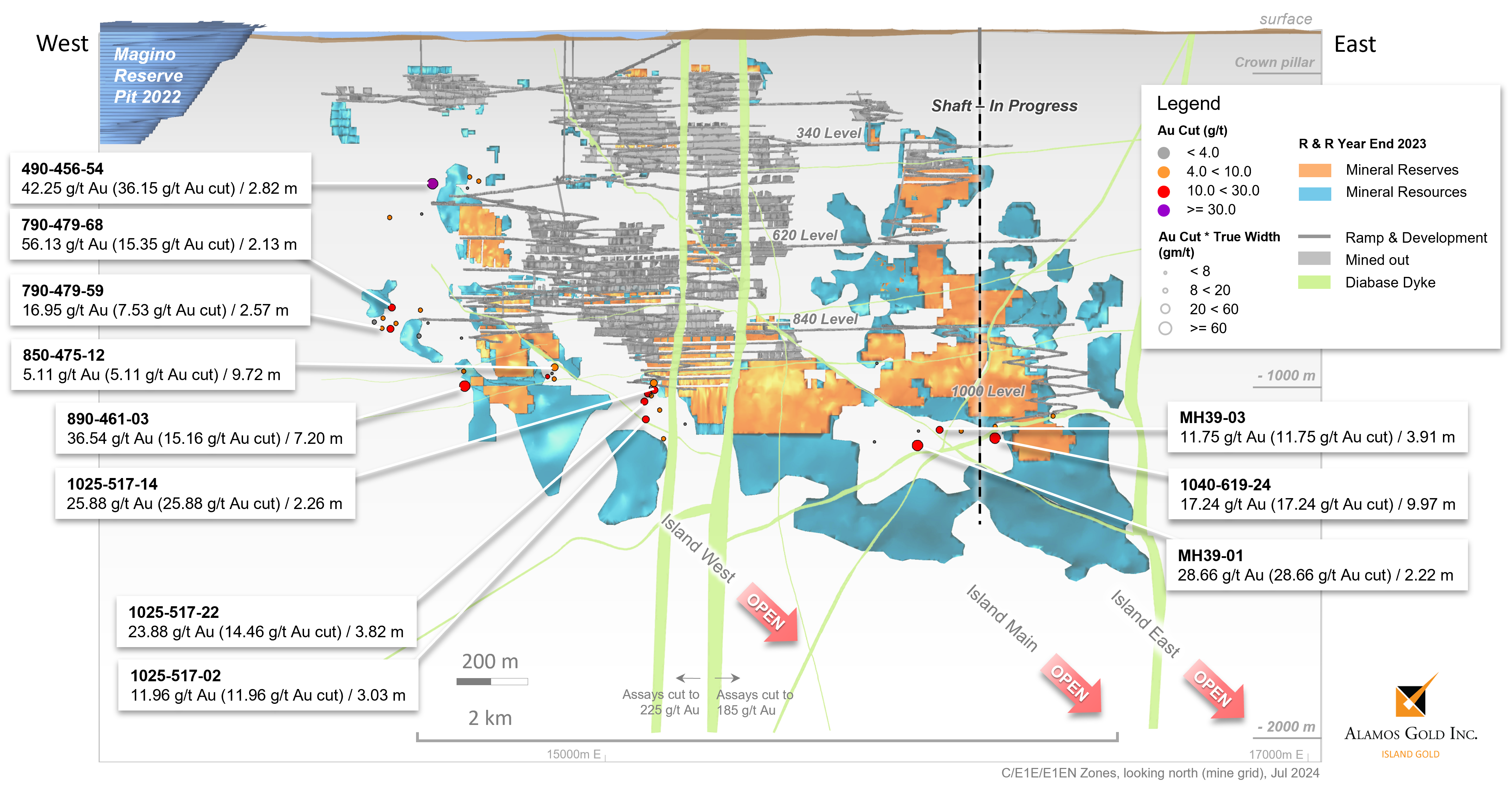
Figure 2: Island Gold Mine – New Underground Exploration Drilling Highlights: Hanging Wall & Footwall Zones
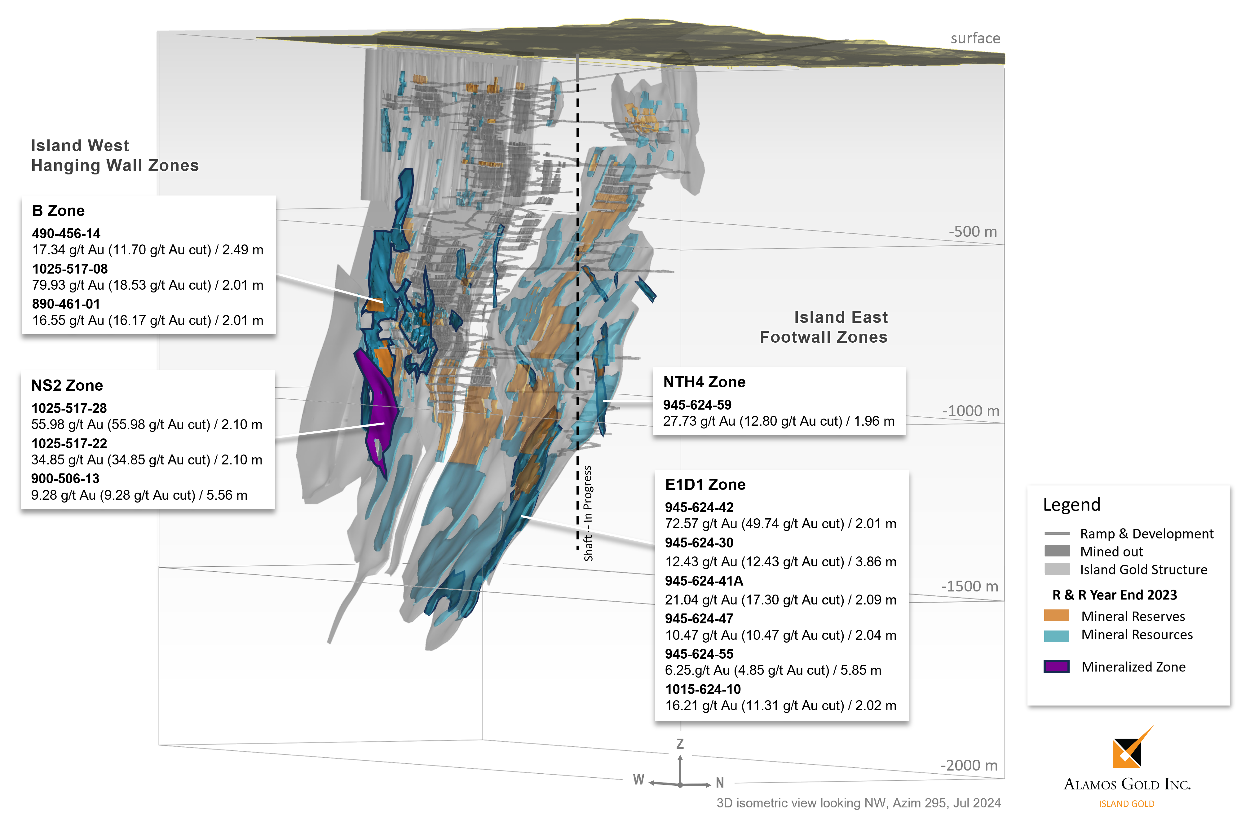
Figure 3: Island Gold North Shear Plan Map – New & Historic Drilling Results
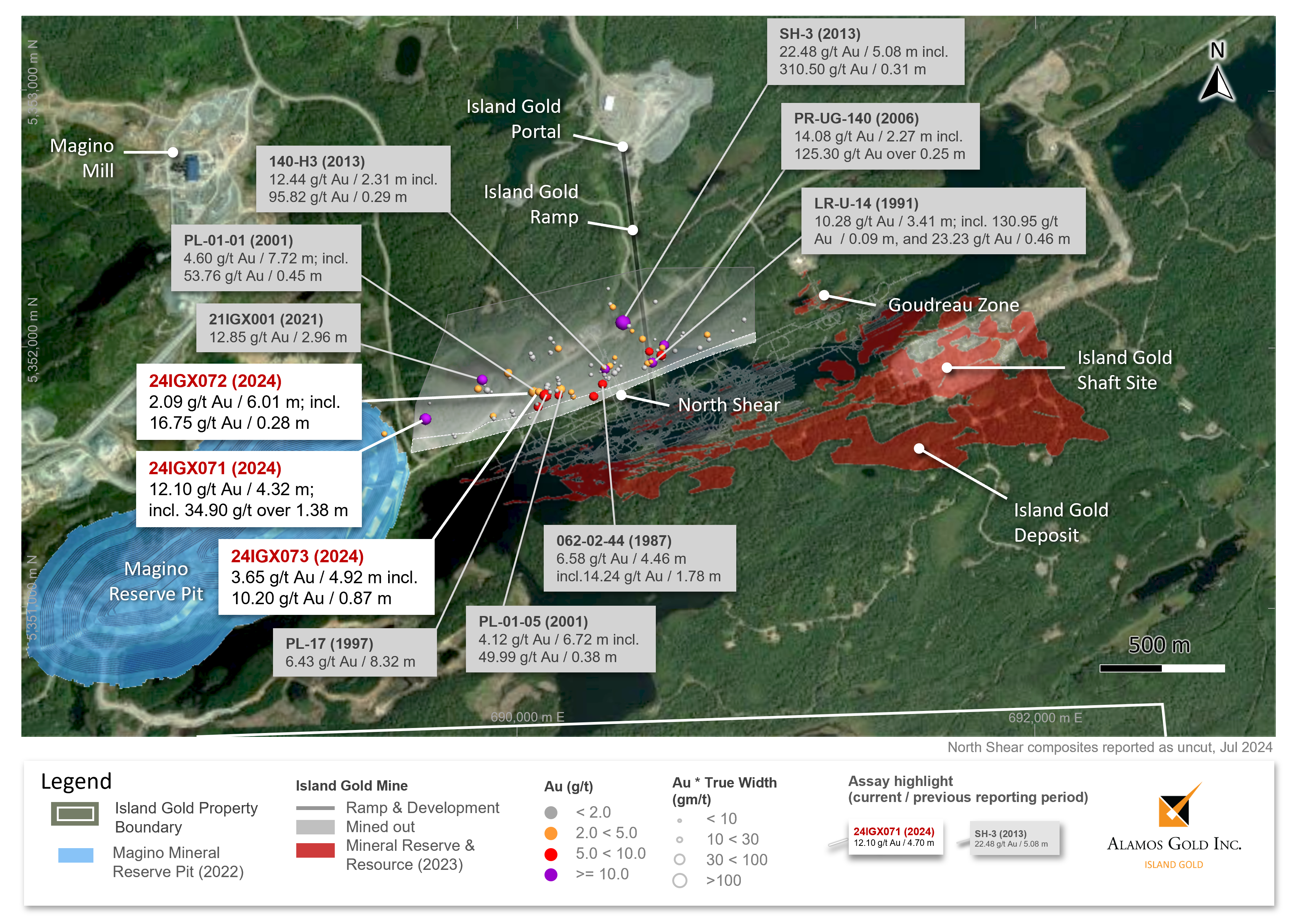
Figure 4: North Shear Longitudinal – New & Historic Drilling Results
Photos accompanying this announcement are available at
https://www.globenewswire.com/NewsRoom/AttachmentNg/f57371d9-973d-4474-a9d3-a78e214e3f79
https://www.globenewswire.com/NewsRoom/AttachmentNg/9579c4c2-ebc5-44e9-bf88-82fa9f6d267e
https://www.globenewswire.com/NewsRoom/AttachmentNg/b4b73c92-2f86-4208-a5e7-aade2fe0ce46
https://www.globenewswire.com/NewsRoom/AttachmentNg/3b8d798b-ae69-43f7-bd42-0541da8d773e

![]()